

Bali now has a number for the land it intends to keep out of development: 56,094.50 hectares. On 29 September 2026 the Governor chaired a meeting at the Kerta Sabha hall in Denpasar, convened by the provincial office of the National Land Agency, to settle the final proposed allocation of Lahan Pertanian Pangan Berkelanjutan, the protected food agricultural land known as LP2B. The results are published on the provincial government’s website, and Governor’s Letter B.25.600.3/14236/TARU/DISPUPR.PERKIM of the same date transmits them to the Minister of Agrarian Affairs and Spatial Planning in Jakarta, through the Director General of Spatial Planning, as the province’s final proposal.
In August I wrote in this column that the most important zoning map in Bali was the one that had not been published yet. That map has now been drawn. It has not yet been enacted, and the distance between those two statements is where buyers need to pay attention.
What the Province Has Published
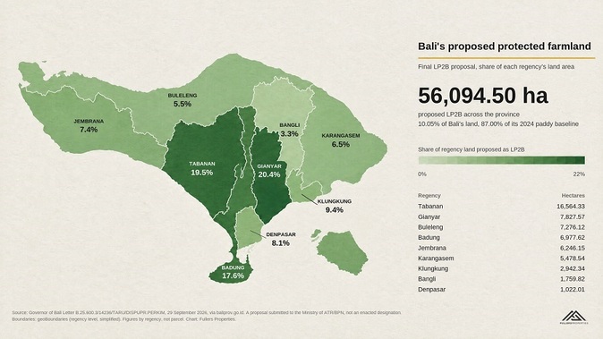
The provincial page sets out a table by regency and city. It gives each area’s administrative land size, its 2024 baseline paddy area under the national ministerial decree, and its share of the final LP2B proposal. Across the province, 64,473.64 hectares of baseline paddy land yield a proposed 56,094.50 hectares of LP2B. That is 87.00 percent of the baseline, matching to the decimal the national minimum set out in the joint circular issued by the Minister of Agrarian Affairs and the Minister of Home Affairs on 19 June 2026. It is also 10.05 percent of Bali’s total land area of 558,282.70 hectares.
The distribution is uneven, and that is the part the headline figure hides. Tabanan carries the largest allocation at 16,564.33 hectares, 19.52 percent of the regency. Gianyar proposes 7,827.57 hectares, 20.40 percent of its area and the highest proportion on the island. Badung, the regency that contains Canggu, Seseh, Uluwatu and most of the villa market, proposes 6,977.62 hectares, 17.56 percent of its land. Denpasar proposes 1,022.01 hectares. Buleleng, the largest regency by area, proposes 7,276.12 hectares, 5.50 percent of its land.
Three districts sit below the 87 percent benchmark against their own baseline: Gianyar at 78.00 percent, Denpasar at 76.23 percent, and Badung at 84.06 percent. Every other regency is above it. The province meets the target as an aggregate, which is how the Minister of Home Affairs said in June the figure would be read, while the three districts with the most development pressure propose to protect the smallest share of what they have.
The Numbers Moved Between July and September
This is not the first version. On 22 July 2026 the Governor and every regent and mayor agreed a provincial figure of 56,098.76 hectares. The province sent a first proposal to the Ministry on 5 August, the Governor’s letter records. A technical verification round followed on 21 September, and the 29 September meeting produced the final proposal at 56,094.50 hectares, resubmitted the same day. The provincial total barely changed. The district figures did.
Tabanan’s allocation fell by 371.90 hectares. Gianyar’s rose by 175.64 hectares. Denpasar’s rose by 56.75 hectares, Badung’s by 55.21, and Buleleng and Jembrana by roughly 43 hectares each. Klungkung did not move. The published page does not explain the adjustments and I will not guess at them, but the lesson for a buyer is plain: a parcel’s position relative to this map can change between one official round and the next, and a map dated July is not the map dated September.
The process is not closed as a political matter either. On 5 October the Regent of Karangasem publicly asked for the designation to be more proportional, saying the regency had roughly 280 hectares left for tourism development and that a reduction of the size proposed would leave nothing. Karangasem’s figure in the final proposal is 5,478.54 hectares, almost unchanged from July. Whether that request has any effect sits with the next stage.
A Proposal Is Not a Designation
The document the province has published is titled, in its own words, usulan final: a final proposal. The Governor’s letter transmits that proposal to the Ministry for designation. Neither the page nor the letter states an effective date, states that any parcel has acquired LP2B status, or says when the Ministry will act. The joint circular of June describes a route in which regions may set LP2B provisionally within their spatial plans rather than wait for the five-year RTRW revision cycle, and the Deputy Minister of Agrarian Affairs has put the national target at 2029. None of that is a date for Bali, and I am not going to invent one.
A separate idea surfaced the same week and should not be confused with any of this. A senior official at the Ministry floated the notion of an offset, in which a developer converting a rice field would fund a replacement paddy elsewhere on state-managed land. Terje H. Nilsen of Seven Stones Indonesia set out the case against it for Bali in a piece on 25 October, and his practical conclusion is the one that matters here: there is no regulation, no mechanism and no price, and the existing prohibitions apply in full.
What is already in force is different. Governor’s Instruction 5 of 2025, issued in December, prohibits regents and mayors from approving the conversion of agricultural land, covering both LP2B and the protected paddy category, and halts changes to their designation in the RTRW and RDTR. The Governor cited penalties under Law 41 of 2009 of up to five years’ imprisonment and IDR 1 billion. Perda 4 of 2026, which I covered in August, froze conversion permits until the 87 percent designation is permanently set. So the binding position for a buyer today is a freeze layered on the existing spatial plans, with a proposed map now sitting alongside them.
Two errors follow from that. The first is treating the proposal as law and walking away from a parcel because a shapefile shades it green. The second, and far more expensive, is treating the proposal as nothing and buying a parcel the map says will be protected on the assumption that the line will move. The published figures show the lines did move between July and September. They did not move in the direction of more developable land.
What We Check Before a Client Commits
At Fullers Properties this has changed how we run the Examine stage of our CLEAR Buyer Method for any land or development site. We ask the planning consultant to overlay the parcel against three layers: the currently binding RTRW and RDTR for the regency, the existing protected paddy designation, and the final LP2B proposal. Where those layers disagree, the discrepancy is recorded with a date and raised before any recommendation to proceed, not after. Our Indonesian legal partners then confirm which instruments bind the parcel today, whether the proposal alters its status, and how any existing approval on it would be treated once the designation is enacted.
The wording we give clients is deliberately plain. Bali has published its final proposed agricultural protection allocation. This does not itself establish a zoning change. Relevant development sites require checks against both the legally binding maps and the proposal before commitment. A proposed exclusion from LP2B is not permission to develop, and a proposed inclusion is not yet a prohibition. The paperwork behind the parcel decides.
The Map Buyers Have Been Waiting For
For most international buyers of finished villas on correctly zoned land, this proposal changes little directly and a good deal indirectly, because it confirms where new supply will not come from. For anyone buying land, a development site, or a project that still exists only on paper, it is the one document to read before anything else, alongside the maps that already bind. Buying in Bali should feel exciting, not uncertain, and in 2026 that depends on knowing which map you are reading. Fullers Properties helps clients read both.